The Far North
mapped from above
Commercial drone mapping, aerial imagery, and environmental documentation for organisations operating across Far North Queensland — from Cairns to Cape York and the Torres Strait.
Built for this region.
Tropical Drone Mapping is based in Cairns and operates across Far North Queensland — coastal and reef environments, remote Cape York communities, Wet Tropics terrain, and Torres Strait. These aren't unfamiliar places. The credentials, experience, and operational approach reflect where the work actually happens.
- FNQ / 01Cairns & Wet Tropics Coast16.92° S · 145.77° E
- FNQ / 02Cape York Peninsula12.62° S · 141.87° E
- FNQ / 03Torres Strait Islands10.58° S · 142.22° E
- FNQ / 04Atherton Tablelands17.27° S · 145.48° E
- FNQ / 05Great Barrier Reef Inshore16.50° S · 146.00° E
Four service areas, one operator.
Each service runs under CASA RePL certification with field workflows shaped by a decade of regional and remote work in Queensland. Scope to suit the program, the terrain, and the deliverables.
Commercial Services
Aerial imagery structured around professional reporting and asset documentation. Suited to commercial property handovers, engineering condition assessments, asset inspections, infrastructure records, and planning support where accurate, high-resolution aerial context is needed.
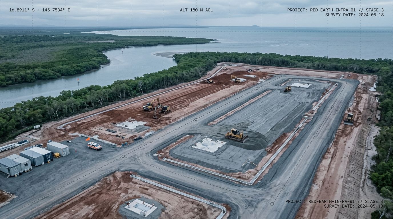
Construction Progress Documentation
Systematic aerial documentation tied to your construction program. Each survey captures a timestamped aerial record of site conditions - structures, earthworks, access, and progress - at scheduled intervals from ground-break through to practical completion. Deliverables are structured for progress reporting, principal and stakeholder briefings, and contract documentation. Consistent capture across a project timeline gives your team a visual record that site-level photography can't provide.
Environmental & Land Mapping
Orthomosaic mapping, terrain analysis, and spatial data collection for land management, conservation, and environmental monitoring programs across FNQ. Suited to coastal and inshore environments, wetlands, riparian corridors, and remote Cape York terrain where ground-based survey is impractical or incomplete. Deliverables include georeferenced orthomosaics, digital surface models, and GIS-ready outputs for direct use in reporting and analysis.
Aerial Photography & Videography
High-resolution stills and video for commercial, tourism, and marketing applications across FNQ. Captured with the DJI Mavic 4 for wide-area and elevated work, and the DJI Avata 2 for low-altitude first-person-view flythroughs, interior approaches, and immersive footage suited to hospitality, resort, and real estate clients. Delivered in formats ready for publication, presentation, or further production.
Operational credentials. Real field experience.
A standalone operation, qualified for commercial drone work in Australia and built on a decade of practical fieldwork in the FNQ region.
Tropical Drone Mapping is a Cairns-based commercial drone operation with formal aviation qualifications and a decade of practical fieldwork across Far North Queensland - including extended time in remote Cape York and Torres Strait environments. Operating in partnership with Heath Design Studio, clients receive spatial data and finished deliverables from a single team.
Spatial data. Sector knowledge. Finished deliverables.
A regional operation built around the work that actually gets done in this part of the country.
Based in Cairns, working across the Far North.
Operating from Cairns across FNQ, Cape York, and Torres Strait. Not a southern operator flying north for a job — the region is home territory.
Aerial capture and finished outputs together.
In partnership with Heath Design Studio, clients receive the aerial data and the finished reports, maps, and communications outputs from a single team.
Coastal, remote, and logistically demanding.
The credentials and experience behind Tropical Drone Mapping reflect the environments FNQ clients actually work in — coastal, remote, sensitive, and often logistically demanding.
Articles, fieldwork notes, and thinking in progress.
Working notes from the field — operational thinking on commercial drone work in FNQ, observations from project sites, and longer pieces on aerial mapping practice.
Why progress documentation is worth doing before something goes wrong
A proper aerial record is the kind of thing you don't think about until you need it - and then you're glad it's there.
Read note
Tropical Drone Mapping is now open for business in Cairns
Tropical Drone Mapping provides commercial drone aerial imagery and mapping services across Far North Queensland - serving construction, infrastructure, environmental, and land management projects that need a reliable aerial record.
Read noteDispatches, direct to your inbox.
Occasional notes on drone mapping, operations, and FNQ fieldwork.
Your project data, organised and accessible.
Every Tropical Drone Mapping project is delivered through a dedicated client portal — a secure, project-specific workspace where you can track survey progress, access delivered files, view interactive map outputs, and download reports.
Live project status
Track where your survey series is up to in real time.
Interactive map viewer
View orthomosaics and flight coverage directly in the browser.
File & data delivery
Organised access to imagery, GIS files, and processed outputs.
Report archive
All delivered reports in one place, downloadable at any time.
Beyond the single survey.
Most aerial programs capture a moment in time. Tropical Drone Mapping is building a continuous monitoring capability for infrastructure, environmental, and land management clients who need ongoing situational awareness.
Designed for remote infrastructure, coastal environments, and long-term land programs across FNQ. If you're planning a monitoring program, early conversations are open now.
- 01Capture
Scheduled, regular flights
You set the frequency
- 02Analysis
Change detection over time
Comparative analysis across your survey series.
- 03Delivery
Data delivery
Customised dashboards that meet your needs and track your requirements.
- 04Intergrate
Data Intergration
Combine with additional sensors and regulators to get the full image of your region
Working on something that needs an aerial view?
Whether you're planning ahead or already mid-project, early conversations are welcome. Get in touch to talk through what aerial mapping or imagery could do for your program.
Or email [email protected] directly.
Commercial operations conducted under CASA RePL certification. Service availability subject to scheduling and operational readiness.